Waterdrive
Water driven rural development in the Baltic Sea Region.
Water driven rural development in the Baltic Sea Region.
The Waterdrive website in Denmark contains information concerning the Waterdrive project funded by Interreg Baltic Sea Region and financial support of the Russian Federation for the purpose of informing about progress and sharing reports primarily under the responsibility of SEGES and Workpackage two including activities, cross sector participation and leadership. The results have emerged from the cooperation in the project case areas in Denmark, Poland, Lithuania, Latvia, Sweden, Finland and Russia. More information about Waterdrive is available on www.water-drive.eu.
WATERDRIVE bridges the gaps between high water quality, nutrient load, drought and flooding targets and the actual opportunities at hand for local authorities and communities.
The WATERDRIVE partnership is designed to achieve longterm impacts and enhance individual and institutional capacities. WATERDRIVE has attracted highly experienced individuals working with water and land use quality issues as officials, advisors, spatial planners, farmers and researchers.
Waterdrive findings and strategic recommendations
Nedenfor kan du se en video om indsatserne for et bedre vandmiljø. Den er relevant for alle, som interesserer sig for vandmiljøet. Videoen varer ca. 12 minutter.
I videoen hører du blandt andet om:
Success-stories & experiences in the partner countries.
The Local Participatory Toolbox will help you to quickly and comprehensively familiarize yourself with some useful methods and tools for facilitating local participation in water management projects. By indicating tips and recommendations, collaboration between different stakeholder groups should be more easily achieved/facilitated. This handbook helps you and gives you some tips and tricks when you are administering/facilitating or leading a water management project but it can also be applied to other thematic projects. It will give some useful recommendations and indicate methods and tools how to achieve cross sectoral stakeholder participation within a project.
The Local Participatory Toolbox serves the purpose to promote local participation processes in water management. As a result, it is important to help the actors on different levels create an understanding of the benefits of cooperation. Target groups are local/regional authorities, farmers/land owners and rural communities found in typical agricultural landscapes around the Baltic Sea Region. The toolbox aims to put more theoretical frameworks for local cross-sector collaboration to a practical and inspirational level by indicating hands-on tools and methods. It focuses on encouraging bottom-up processes. This is anticipated to help with resolving the lack of local cross-sector collaboration in the area of managing water resources. The Local Participatory Toolbox focuses on the sociological context and will help to identify joint objectives, facilitate cooperation and prepare action plans. The output will be used for building capacities and as a source of inspiration for the target groups aiming to improve participatory local water management.
Local Participartory Toolbox managed by Pheno Horizon and CDR Agricultural Advisory Center Brwinów, Krakow.
Waterdrive - Planning Toolbox managed by Pheno Horizon.
See the Waterdrive online workshop: Interactive digital portal for action – tools and living labs.
All focus group meetings in all partner countries has been affected by the whole covid-19 situation from 2020-2021 and has generally not been implemented as planned in the Waterdrive project.
Focus groups in the partner countries.
New services for water management in agricultural landscapes - a catalog of ideas and experiences
This catalog of new services is developed by partners in the Waterdrive project funded by the EU Interreg Baltic Sea Regional Program.
The intention is to introduce and discuss new services for strengthening water management in agricultural landscapes of the Baltic Sea Region.
Hopefully, it will inspire the reader to take further action in this direction. The catalogue is mainly focused on improving management on catchment level through the services of local facilitators, catchment officers, water advisors or catchment teams. The catalogue starts out with introducing some prerequisites and basics for successful implementation, then continuing with examples of water advisors in Poland, catchment officers in Finland, Sweden and Denmark.
Then finally presenting a vision for a governance structure and a framework for local water management plans implementation in Denmark.
New services for water management in agricultural landscapes - a catalog of ideas and experiences
See the Waterdrive online workshop: Catchment officers services and new services – water and landscape management
The complexity of many water and land management situations is related to the multiple issues, stakes, goals and parties at hand, as well as the difficulties of predicting the consequences of measures taken in socioecological systems. Such complexity suggests that progress is only possible if we continuously learn from our experiences. Three factors can be used to represent the different domains in which progress can occur: relationships, procedures, and substance, labelled “the progress triangle”. Decisions and multistakeholder partnerships must consider all these domains: Collaborative water and land management; tools and procedures; strengthening of relationship among involved parties. This progress triangle also reminds us that substantive progress depends on how good we are at implementing innovative methods. Substance represents the issues, often both practical and scientific, that are to be managed or reached. Procedure and methods represent how we choose to work together, from overall process design to specific tools to reinforce learning. Relationships.
Meeting between all stakeholders. Farmers, universities, agencies, catchment officers and the advisory service . Photo: Frank Bondgaard, SEGES:
Material and inspiration on leadership:
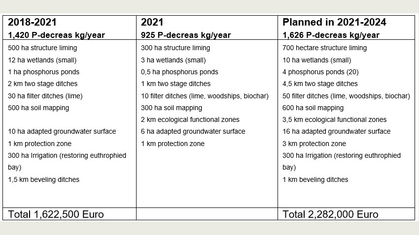
Measures in case areas
Environmental measures used in case areas in the partner countries.
The work in Waterdrive will focus on implementation of new drainage measures in Denmark at subcatchment level.
Constructed wetlands with woodchips (Woodchip bioreactors) will be implemented in a pilot scheme in 2019. Intelligent bufferzones in 2020.
Saturated bufferzones are now being scientifically investigated in Denmark – the measure is in progress in the United States. Wetlands have been implemented as environmental measures in Denmark for more than 25 years.
Have a look at all of the environmental initiatives in Denmark in the catalog: Mitigation measures catalogue. For targeted agroenvironmental nutrient mitigation.
Between 2019 and 2021, eight Waterdrive case areas were involved in multiactor water management engagement. Landowners, local municipalities and stakeholders, government agencies, the advisory service, catchment officers and private companies provided input as to how to solve the various environmental challenges brought about by the leaching of nutrients, the loss of biodiversity, climate change, drought and flooding in the Baltic Sea region.
Waterdrive case areas leaders:
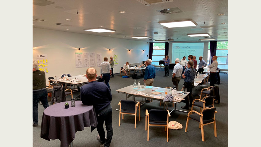
The partner workshop held on 5 May 2021 was based on the work undertaken in the Waterdrive case areas between 2019 and 2021. Prior to the meeting, the case area leaders singled out several
innovations and key findings based on the case area work. The main focus was to identify the most important innovations and key findings to ensure the implementation of environmental measures in the Baltic Sea Region. See the conclusions in the report:
New and innovative solutions plus key findings in Waterdrive case areas 2019-2020
Between 2019 and 2021, eight Waterdrive case areas was involved in multiactor water management engagement based on focus group meeting between landowners, the local municipalities, stakeholders, government agencies, the advisory service, catchment officers and private companies.
The stakeholders provided input to how the various environmental challenges as leaching of nutrients, loss of biodiversity, climate change, drought and flooding should be handled in the future in a more consistent way.
The work with focus groups in the waterdrive case areas has been a real challenge in relation to the whole covid 19 situation from March 2020. Regardless the situation, the Waterdrive was carried out by highly experienced environmental consultants, catchment officers and wateradvisors in the Baltic Sea Region. The report Waterdrive case areas. Overview 2019-2021 has joined together the description of each case area, the local conclusions, implementation- and investmentplans. All the work undertaken in the case areas is are available on websites www.water-drive.eu and www.waterdrive.dk as success stories, case areas, focus group meetings and measures.
Waterdrive case areas. Overview 2019-2021
Wetland project restoration of Odense Å. Photo: Rambøll.
In the Waterdrive project the catchment area of Odense Fjord has been selected as a case area. The catchment area of Odense Fjord is a part of the main water catchment area of Odense Fjord and constitutes an area of 105.600 ha, of which the agricultural area constitutes approximately 63.960 ha.
”According to the River Basin Management Plan, nitrogen emissions to Odense Fjord must be reduced by a total of 549,3 tonnes N. Of this, a reduction of 345,8 tonnes N has to be reached by 2021. The remaining reduction requirement has been postponed to the third Water Plan period. The reduction requirements correspond a reduction of agricultural nitrogen emission by 38 % before 2021 and by a full 64 % in total. It is a very extensive reduction requirement with major consequences for agricultural production, if most of the effort is to take place on cultivated land. For this reason, it is relevant to examine the options of either completely or partially replacing restrictions on cultivated land with nitrogen measures on the edge of or outside of cultivated land.”
The Waterdrive project collaborates with landowners in two selected subcatchments to Odense Fjord, as it is impossible to work with all landowners in this very large catchment area. Instead we have decided to focus on a smaller area, which according to the program SCALGO should be potentially well suited for the establishment of drainage measures and wetlands. In Denmark, we have approximately 3000 subcatchments called ID 15 each of them with an individual number. The areas are called ID 15 because they each represent approximately 1500 hectares and the main purpose is to use the retention in the specific area in the action plan.
Theoretically it is possible in the catchment 42.320.119 to establish approximately 6 hectares of constructed wetlands with an effect of 2.478 kg N/year and 20,4 – 23,3 kg P/year at a cost of approx. 591.000 €. Realistically, it is unlikely that this amount of hectares will be realised. The reasons for this may vary between places and landowners.
Theoretically there are many possibilities of placing the measures, and the farmers are generally positive towards making the measures, but in reality we meet many challenges. Based on this project and my job as a catchment officer my experience is that some of the reasons are:
I think it would promote solutions, if first of all rules were less strict, if we had more possibilities and if we (advisors and representatives from the municipality and the state) generally learned to cooperate more closely in order to see all possibilities and choose the best. We ought to have the same goals.
Waterdrive has worked for a concept for a localbased watermanagement plan in Odense Fjord catchment from 2020-2021.
Companies, institutions and organizations together in a unique collaboration to improve the environmental conditions in Odense Fjord. The parties have assumed a responsibility to take care of the environment around the fjord. Odense Fjord has a beautiful and varied environment, which contains important habitats for both animals and plants. The central parties have joined forces to bring Odense Fjord in good ecological conditions there are sustainable for both the environment and business. The cooperation is based on the latest available knowledge about the condition of the fjord and its pressure factors from the surroundings.
Several of the parties has already worked in various ways on initiatives to improve the state of Odense Fjord, therefore they bring experience and new knowledge into the joint cooperation. Through knowledge sharing, supply of resources and forces in center, the parties will work towards a common goal of a robust and clean fjord. This report describes the collaboration with proposals for how it is implemented, who the actors are and how the organization as well as the framework and principles for partnership can unfold.
The partnership:
Odense Municipality, Kerteminde Municipality, Nordfyn Municipality, Faaborg Midtfyn Municipality
District heating Fyn, Odense Renovation, Water Center South, Port of Odense, Danish Society for Nature Conservation, Funen, Agriculture and food, Centrovice, Southern Danish University, Syddansk Universitet, SEGES, H.J. Hansen, Marius Pedersen, Emmelev A/S
The partnership for improving the aquatic environment in Odense Fjord
English version: Waterdrive - local multiactor cooperation
Danish version: Lokalt samarbejde baner vej for det gode vandmiljø
Waterdrive meeting in the partnership 1. October 2021. Photo Flemming Gertz, SEGES.
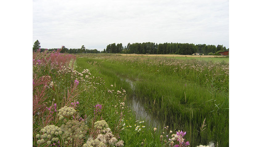
A twostage ditch, with both flood plain on both sides. Photo: Mikko Ortamala.
The Gammelbacka stream, also called Storängsbäcken, flows from the forests of Kuninkaanportti and Ernestas through Eestinmäki and Karjalaiskylä fields through the built-up urban area and park area of Gammelbacka to the issue of river Porvoonjoki. The length of the stream is about seven kilometers. Salmo trutta have been restocked in Gammelbacka stream in the urban area and park area. This part of the stream was restored in 2014.
Storängsbäcken has its own Drainage corporate body. Drainage corporate bodies are organizations that consist of those land owners that gets benefit or profit of the drainage. Drainage corporate bodies have been established in Finland since 1883 for maintaining the ditches. Storängsbäckens Drainage corporate body was established in 1932. First drainage plans have been made in 1916.
The most of drainage corporate bodies are not active and maintenance of the ditches has been delayed. Many cases drainage corporate body has not been active in 50 years. Farmers are trying to excavate small shots of the ditch in their own lands with locally-based contractors and the results are largely qualitatively weak.
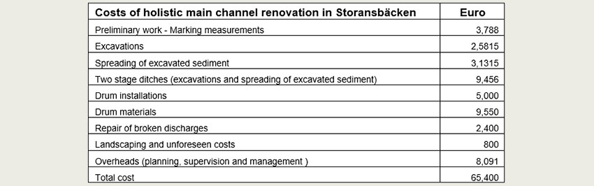
The drainage main channel of Storängsbäcken is a typical case, not renovated during decades. The problems consist of small difference of field surfaces and channel water level. By drainage planning norms this difference should be at least 80 cm. This problem was caused by erosion which resulted silt and mud accumulation to the channel and also depression of the soil. Humidity and floods have during the years compressed and weakened soil structure and farming capacity, and also increased depression.
In large-scale holistic water management and maintenance demands a clear division of roles for different stakeholders. Planning has been relocated from authorities to private service providers and advisory together with guidance is transferring to advisory organizations. Juridical review remains to state authorities and province administration are taking over the financial subsidizing. There is a need of a clear “command chain” from the catchment area to water bodies. The links of this chain would be drainage cooperatives, authorities, fishery regions, land owner cooperatives, foundations, associations, planners, contractors, scientists, advisers, farmers and land owners. Catchment officer could offer a link between all of these stakeholders.
Responsibility of actions could not remain to separate actor of the chain, but we need an operative set. Everyone should have a clear approach, which leads the activities towards operational basic and local drainage including surface water management. As a result should be the good status of waterbodies according to the demands of Water Framework Directive. Catchment area wide cooperation groups, negotiation committees and foundations which coordinate the projects have been solutions adapting and combining the actors, enabling the formation of operative chain.
A systematic, phased implementation on a catchment-scale is more likely to secure better results concerning both sufficient drainage on agricultural lands as well as decreased nutrient load. In order to decrease the renovation debt, a more systematic and planned approach should be strived for in contrast to the current unsystematic and random operating model/activities.
Information about holistic water management should primarily be targeted to farmers, landowners and drainage corporate bodies in the risk areas. The regional authority (in Finland ELY-centre) would be a natural actor to coordinate the targeting of funds to the most critical areas. A regional coordinator could be funded by state subsidies either through a project or a new form of support or service.
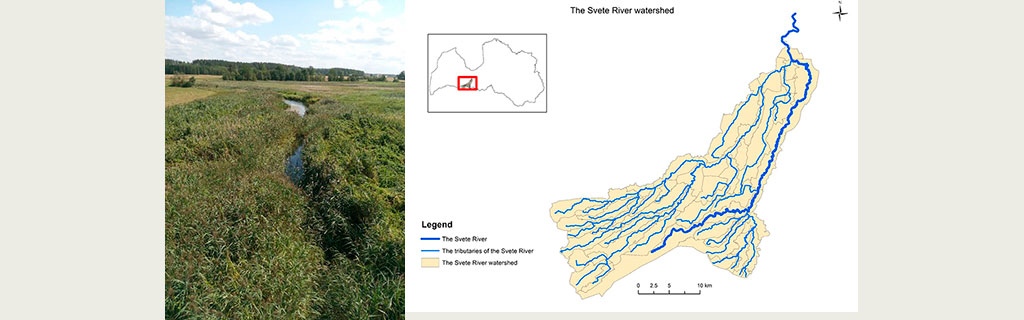
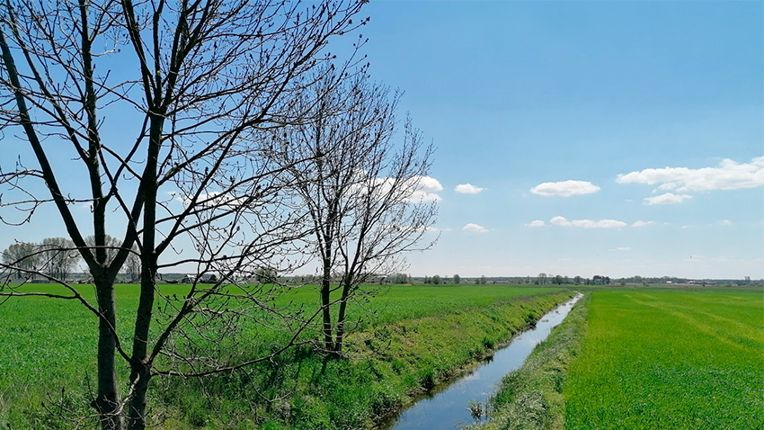
Svete River in Latvia. Photo: Ingars Rozitis.
Water driven rural development in the Baltic Sea Region” Nr. R094 WATERDRIVE specific objective is clear waters. To increase efficiency of water management for reduced nutrient inflows and decreased discharges of hazarious substances to the Baltic Sea and the regional waters based on enhanced capacity of public and private actors dealing with water quality issues. Rivers in Jelgava Local Municipality are under stress, affected by high nutrient loadings and eutrophication which leads to rivers’ overgrowth. Within the WATERDRIVE project Jelgava Local Municipality as local authority wanted to rise awareness on condition of the rivers and the need of river cleaning. Svete river is a Public river. It is a tributary of the left bank of the Lielupe river – the biggest river in Jelgava Local Municipality. The total length of Svete river is 123 km, of which 75 km are in the territory of Latvia and 65,4 km in Jelgava Local Municipality. It flows mostly through agricultural lands of Zemgale region plain. Leaching of nutrients from agricultural lands contributes to the growth of aquatic plants, the management on floodplain meadows is insufficient, biomass accumulation in the river bed results in disturbed natural river flow. Also the natural processes of rivers are additionally influenced by relatively warm winters due to climate change, which do not form a thick layer of ice that is able to naturally clean the river bed and shoreline during spring floods.
In the Svete River catchment the local “test catchment officers” has focus on teroretical implementation of wetlands restauration, two stage ditches, phosphorus dams, constructed wetlands and intelligent bufferzones. Estimation of costs is a real challenge without scientific tests sites with all these new measures and no agricultural schemes to support implementation of new agrienvironmental measures.
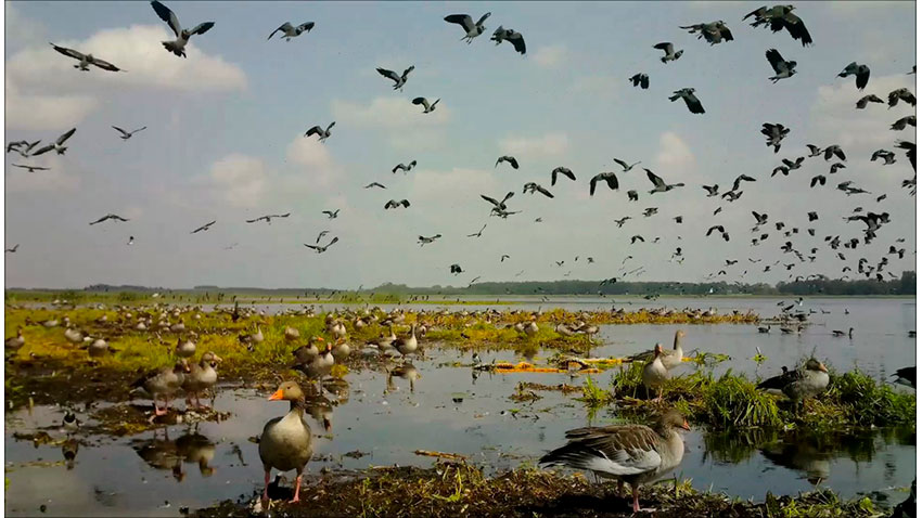
A gaggle of geese flocking in Žuvintas Biosphere Reserve during migration. Source: Žuvintas Biosphere Reserve Directorate.
The Dovine River Basin covers an area of approximately 588.7 km2 and is located in the southern part of Lithuania (see Figure 1). The basin is one of the small catchment areas of the larger Neman river basin, which covers around 75% of the territory of Lithuania and is the 4th river basin in size in the whole Baltic Sea Region.
The Dovine river catchment (see Figure 3) consists of a network of rivers and water bodies formed by five big lakes (Dusia 23,3 km2, Zuvintas 9,3 km2, Simnas 2,4 km2, Giluitis 2,4 km2, Amalvas 1,9 km2) and a number of rivulets and small lakes. Within the borders of the basin lies one of the oldest and most unique protected areas of Lithuania –Zuvintas Biosphere Reserve. A part of the reserve is protected by the RAMSAR convention since 1993 and in 2011 the reserve was enlisted into UNESCO’s Man and the Biosphere Programme.
In 19th and 20th century, land reclamation and wetland drainage projects were carried out in order to expand agricultural lands and make us of fertile lands in the Dovine river basin. Therefore, the natural hydrological cycle was interrupted, many wetlands were drained and meliorated to provide space for agricultural lands.
Currently, most of the surrounding areas are productive agricultural lands (productivity is higher than the average of the country). The forest cover is scarce, i.e. approximately 16 % of the area (the average in Lithuania – 33%). As a result, the water quality in the lakes within the Dovine river catchment, is remarkably deteriorating and results in eutrophication of the water bodies within the catchment. Zuvintas lake (Figure 2) in particular and the whole wetland system in the reserve is under heavy pressure of leaching of nutrients mostly from agricultural activity in the basin, which is degrading the ecosystems and their values.
In the Zuvintas Reserve and agriculture case area the case area leaders are trying to improve recommendations for the river basin management plans. Monitoring activities are crucial in interactions between all stakeholders.
Bedlno commune lies in the zone of the lowest precipitation in Poland. Their average annual sum is 550 mm, but in individual years it can be much lower. Lack of precipitation causes the phenomenon of agricultural steppe.
The area of the Kutno County is an important agricultural production area in the Lodzkie province in central Poland. The high quality of soil had contributed to the development of intense agriculture and thus to the conversion of the natural hydrogenic landscape (peatbogs and marshes). Only 5% of the county’s area reminded covered by forest. Land acquisition was based on the drainage of the area and regulation of rivers, followed but changes in the dynamics of water flow in the landscape. Intensive plant production resulted in water pollution, especially with nitrogen compounds. Nowadays the situation gets worse due to superimposed impact of climate change, namely frequencies and duration of both hydraulic and agricultural drought. Yield loss results in increased interest of farmers in water retention and improvement of its quality.
Bedlno Commune, one of 10 communes in the Kutno County, has been selected for testing Waterdrive approach in the small agricultural catchment scale. One of the main reasons for choosing the commune was the location of the Stradzewski Channel basin, which lies entirely within the commune and is a system linked to the drainage system. The Stradzewski Channel is 14 km long and its catchment area is 5 331 ha. The second factor was that the Bedlno Water Company (association of farmers) is one of the most effective water company in the Lodzkie Province.
The start of WATERDRIVE project corresponded with the reorganisation of the water management system in Poland. in January 2018, the State Water Management Company Wody Polskie was established, which entailed the transfer of responsibility and competence for water management from multiple actors into a single handover at the level of the whole country. However, water companies remained an important local actor in water management in agricultural areas. These are voluntary associations of farmers who own the land through which the drainage system runs. The municipality may also be a member. Voluntary contributions paid by farmers form their budget. They can raise funds for investment. As a result of the reorganisation, the lack of communication between the two main actors, i.e. the national water authority and water companies, has become a serious problem. Supporting communication between them was one of the main goal of WATERDRIVE activities.
During the project, there has been an improvement in the cooperation between Bedlno and Zduny Water Companies and Wody Polskie (unit: Catchment Water Management Authorities in Łowicz), which has resulted in joint, complementary actions, e.g. controlling the outflow from drainage system (the socalled river channel retention). Facilitation by regional (Marshal Office of Łódzkie Voivodship) and local authorities (Bedlno commune and Zduny Commune) was important factor to strengthen their cooperation.
A significant factor affecting work in the Kutno County case area was the occurrence of severe drought in 2018 and 2019, which had impact in agricultural production. The scale of the problem of drought effects in whole Poland is evidenced, inter alia, by the fact of compensations paid and the level of drought risk disaster aid for farmers, which amounted to 2.07 billion PLN in 2018. In 2019 ca 355 thousand applications for compensation for losses worth over 2.3 billion PLN were implemented. The droughts affecting farmers and residents have turned water management from a theoretical research task into an important element affecting agricultural production.
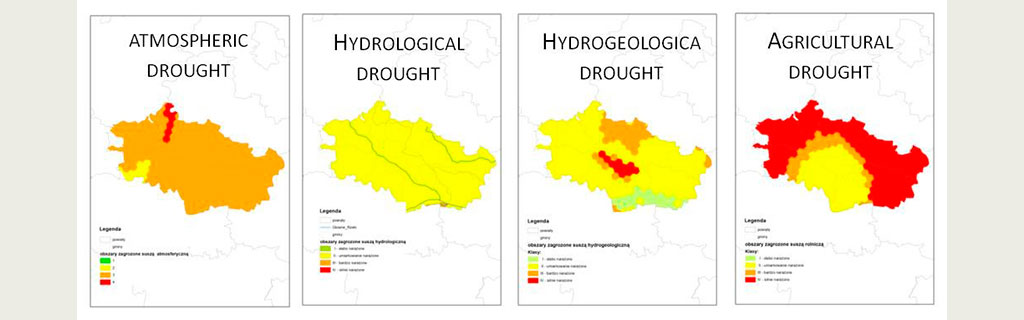
Risk of atmospheric, hydrological, hydrogeological and agricultural drought on the basis of the "Plan for preventing the effects of drought in the water region of Central Vistula" of the National Water Management Authority in Warsaw 2017.
The discussion about the possibilities of water retention in agricultural areas was the main topic of the 1st Local WATERDRIVE Meeting, which took place in February 2020 in Bedlno. The meeting was attended by farmers from Bedlno Commune (water company, farmers, community council), representatives of Wody Polskie (local, catchment, regional and national level), water companies and local authorities from Kutno County, regional authorities, agricultural advisors, and experts. Stakeholders identified the use of the drainage system as a basic tool in the fight against drought. Renovating the drainage system and switching to a controlled drainage system allows water to be collected in open ditches and underground pipes through damming facilities. The result of the meeting was a joint action on the existing hydrotechnical infrastructure by the Bedlno Water Company and the Wody Polskie. Through weirs on the tributaries of the Bzura river, located in the Bedlno commune, water was dammed up by storing it in drainage systems and riverbeds. These activities are part of the national program "River cannel retention" launched by Wody Polskie in April 2020.
The "River cannel retention" programme has shown the potential for water retention in agricultural areas but also the need for major investments in repairing or reconstructing drainage systems and damming facilities. The funds allocated for maintenance works and investments in water retention in agricultural areas were insufficient. The high level of agricultural losses due to the drought gave a strong impetus to water retention measures by the Ministry of Agriculture and Rural Development, which started discussion with the European Commission. As a result of the dialogue, funds will be mobilised under the RDP 2021-2023 to increase water retention capacity and prevent flooding and drought in agricultural catchments.
Local work at commune/small agricultural catchment level on the possibilities to upgrade the drainage system shows two aspects in addition to the financial aspect that should be solved. One of them is the lack of access to maps and digital data. In the case of the Stradzewski Channel and the Igla River, it was necessary to collect maps of the drained infrastructure, which are important for the target location of activities in the catchment. Paper maps (1: 2 000), which are part of the documentation from 1960-1970, have been scattered in the archives of water authorities and farmers. An inventory of melioration devices and digitalization of melioration maps are indispensable.
The second conclusion is that an Action programme should be developed at the level of the small agricultural catchment as a starting point for further actions. For the modernisation of the drainage system it is necessary for the project office to produce design maps, hydrological and hydraulic calculations and the final spatial concept. These analyses will form the basis for technical documentation and permits. Preliminary estimated cost of analysis is ab. 45 000 euros. The development of the of drainagerelated technical documents for building damming facilities in drainage ditches is similar in cost. However, this phase of work has not found a source of funding at the moment.
However, the Action programme should include two main elements: the modernisation of the drainage system towards controlled run-off, and the application of naturebased solutions. The use of naturebased solutions (NBS) such as buffer strips, midfield afforestation, restoration of wetlands or construction of artificial wetlands must be backed up by a strong previous education campaign among farmers. Understanding the impact of NBS measures on increasing water retention in the landscape, influence on water selfpurification processes and increasing biodiversity will be crucial for the acceptance and cooperation of farmers in the implementation of the measures. Planned ecoschemes in the new RDP perspective and climate change adaptation actions in the Regional Operational Programmes 2021-2027 may become important drivers for implementation of NBS measures in agricultural areas.
Multistakeholder cooperation started during the WATERDRIVE project found its continuation in official structures as a part of Local Water Partnerships in Kutno County. The initiative to create Local Water Partnerships was taken by the Ministry of Agriculture and Rural Development and the Agricultural Advisory Centre in Brwinów in cooperation with the Provincial Agricultural Advisory Centres in 2020. The aim of the partnership is to diagnose the condition and principles of rational water management and drought prevention in the district. In the future, it will probably also be able to obtain funds for studies and expert opinions on water retention in agricultural areas and give opinions on planned investments.
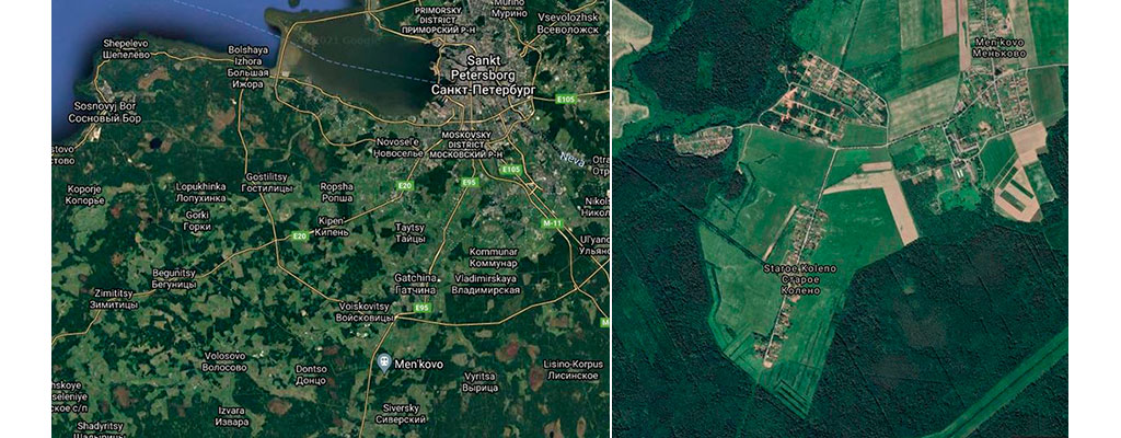
Upcomming testsite at the Agricultural experimental field nearby Men’kovo, Leningrad oblast. From Google Maps.
Suidariver flows through the territory of the Men’kovo Experimental Station owned by the Agrophysical Institute. There is 173.8 hectares at the station, the catchment area are 1,96 km2. The water in Sudia Riveris characterized as "polluted" (class 3, category "a") in 2018.
The agricultural fields at Men’kovo Experimental Station could in the future has a function as a scientific testsite with agrienvironmental measures and in the same time be a demonstrationarea for agricultural advisors and farmers.
In the case area there has been focus on:
The next step is to select 1-2 suitable and effective measures at the Men’kovo Experimental Station. Consultation with drainage experts on the measures. Presentation and approval of plans with the management of the AphI. Draft proposal for technical project of the construction (implementation) of the measure in the fields of the case area.
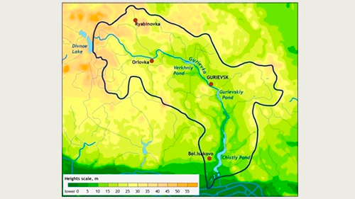
According to the original Waterdrive project plan, the case area selected as the study area was the catchment area of the Upper Guryevka River pond, which is part of the main catchment area of the Guryevka River.
The total catchment area of the drainage channels is 1,030 ha, of which 490 ha are agricultural areas.
The choice of the project area was determined by the fact that earlier in the WaterNets-RU project, under the ICLD programme (cooperation between Guryevka municipality, Russia and the municipality of Västervik, Sweden), data had been collected on studies of the physical and chemical parameters of the Guryevka River water. And within the Waterdrive project we wanted to use the results of the WaterNets-RU project
The Guryevka River (Mühlen Fluss) is a small river in Kaliningrad Oblast, the right tributary of the Pregolya River. The Guryevka River runs in an arc around the city of Kaliningrad, through the Guryevsk urban district.
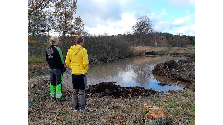
Wetland meeting with the entrepreneur. Photo Anders Fröberg.
Västervik Municipality is located in southern Sweden, in the north of Kalmar County with the Tjust archipelago and the Baltic Sea in the east. Västervik covers one of the largest municipality areas in southern Sweden. The land area covers 1 875 km² and there is almost as much water area as land area.
Agriculture and forestry are important sectors in Västervik. The tourism industry is also important for Västervik, as the municipality receives about 1.5 million visitors annually.
Västervik Municipality has a long coast and an extensive archipelago. It provides many opportunities for development, but also includes responsibility for the Baltic environment. Västervik archipelago, covered by about 5000 islands, offers a variety of outdoor activities and a rich fish selection. Most of the bays are deep with a shallow mouth. The exchange of water between the inner deeper part and the open sea is low. This makes benthic ecosystems particularly vulnerable. The poor water circulation leads to nutrient-rich water and bad oxygen conditions at the bottom. As Västervik is characterized by its proximity to the Baltic Sea, the eutrophication problem is palpable. Coastal Water sensitivity to eutrophication is higher in the inner archipelago. The symptoms of eutrophication have been obvious; including increased distribution of algae’s, decreased water transparency and reduced opportunities for recreation.
Västervik has been working for many years in a holistic way to reduce the nutrient load. Sustainable work (year after year) with advising, local projects and high requirements in wastewater treatment and agriculture has been the method. Always in collaboration with stakeholders, farmers and owners of property/houses. Västervik has invested in improved sewage treatment plants. Recently the renovation of the Gamleby municipal wastewater treatment plant was completed. The plant has a modern technology with remote monitored processes and high nitrogen reduction. Västervik has set high requirements for small private wastewater treatment systems. An adviser has during several years been working with areas with summerhouses. Information and discussions about problems and solutions for sustainable wastewater has been in focus.
Since the anthropogenic nutrient load to the coastal waters is dominated by agriculture the municipality is focusing on reducing emissions from agriculture. Many different measures have been successfully developed and implemented by local farmers. Some examples are; construction of wetlands, liming to improve soil structure, and two-stage ditches, mussel farming, etc. A prerequisite for success is that measures can be done with economically sustainable methods.
Theme Water is an intersectoral body for water issues in Västervik that ties together various municipal “roles” of authority, development, wastewater treatment, etc. TW was formed in 2011 and includes the politicians in the presidiums of the Municipal Government, the Department of Environment and Planning and Västervik Energy & Environment AB together with the department managers and project leaders for municipal water projects.
The catchment officer in Västervik takes part in the national project LEVA (Local engagement for water). In the project, local catchments officers are financed in 20 pilot areas in Sweden to support local actions and measurements against eutrophication. Catchment officers is a way to improve and speed up the implementation and amount of voluntary measures being made in the agricultural landscape.
The project is led by the Swedish Authority for Water and Marine Management together with the Swedish Board of Agriculture, The County administrative boards, the Water district authorities, and the Federation of Swedish farmers as active partners. The method and work with advising services in Västervik are a model for the pilots. Succes factors “the Västervik method”:
The result of this strategy from 2018-2024 is implementation and investment in a lot of different environmental measures to prevent.